Skip to content
Vegetation-Hero-1

Smarter Vegetation Intelligence. From Space to Street Trees.

Geoneon Vegetation delivers accurate, scalable vegetation structure mapping — from national ecosystem models to individual tree crowns.
PRODUCT OVERVIEW

What is Geoneon Vegetation?

Geoneon Vegetation is a modular, AI-powered mapping solution that estimates vegetation height and density from satellite and aerial imagery. Built to support decision-making across government, environment, and infrastructure sectors, it scales from city trees to national ecosystems. Our three modules — Urban Canopy Monitoring, Forest Monitoring, and Wildfire-Prone Vegetation Mapping — provide targeted insights to manage risk, support planning, and track change over time.
FLEXIBLE TIERS

Choose Your Resolution

Geoneon Vegetation is available in two tiers — both powered by our AI engine trained on billions of pixels of LiDAR-aligned data. Whether you need nationwide vegetation structure or tree-by-tree insights, there’s a tier to match your project.
  • 01 Standard
  • 02 Advanced

Scalable mapping from Sentinel-2 imagery

  • 10m Resolution
  • Canopy height (average, min, max)
  • Foliage cover (percent crown cover)


Tree-level mapping from satellite or aerial imagery

  • Sub-metre Resolution
  • Tree canopy segmentation
  • Height estimation
TAILORED TO YOUR NEEDS

What Can You Do with Geoneon Vegetation?

Geoneon Vegetation includes three powerful modules, each purpose-built for real-world use cases. Whether you are managing urban canopy, tracking forest change, or mapping wildfire-prone areas, these modules deliver actionable intelligence.
URBAN CANOPY MONITORING

Support cooler, greener, more equitable cities

Track tree cover, height, and distribution across streets, suburbs, or entire cities. Used by planners, councils, and regulators to guide greening programs, enforce compliance, and reduce heat exposure.

Urban-Canopy-Mockup-2-1
FOREST MONITORING

Monitor forest health, loss, and regrowth

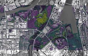
Detect vegetation change over time using satellite data. Identify canopy loss, degradation, or recovery — and feed data into ecosystem models or reporting frameworks.

Forest-Monitoring-2
WILDFIRE-PRONE VEGETATION MAPPING

Map vegetation to support bushfire planning and regulation

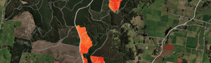
Generate vegetation overlays aligned with national or local wildfire-prone area definitions. Use for bushfire zoning, hazard overlays, and planning scheme compliance.

Wildfire-Prone-Mockup-1
SEE THE RESULTS

Visualise the Impact

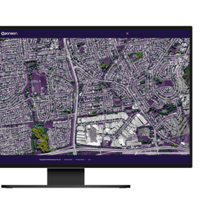
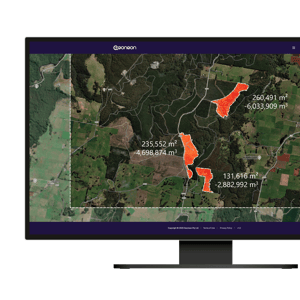
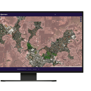
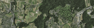
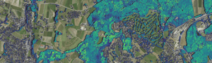
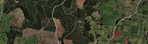
Bring your data to life with side-by-side comparisons that show how Geoneon Vegetation transforms raw imagery into meaningful insights — from broad-scale mapping to individual tree segmentation.


Sentinel-2 to Structure

View how high-resolution satellite imagery is converted into vegetation height layer using our Standard product.

Comparison-1a-1
Sentinel-2 imagery
Comparison-1b-1
Vegetation Height (Standard)

Very-High-Resolution to Tree-Level Structure

See high-resolution outputs from our Advanced product, including tree segmentation and height estimation.

Comparison-2a-1
Very-High Resolution Imagery
Comparison-2b-1
Tree Segmentation + Height (Advanced)

Change Over Time

Explore multi-epoch visualisations that reveal vegetation loss, regrowth, or seasonal change — ideal for monitoring forest health or land clearing.

Comparison-3a-1
January 2024
Comparison-3b-1
Change Detection Over Time (Jan 2023 → Jan 2024)
UNDER THE HOOD

How It Works

Geoneon Vegetation combines the latest in Earth observation and artificial intelligence to deliver vegetation intelligence at any scale. Here is how it all comes together:

1
Earth Observation

Global satellite and aerial imagery

We use high-resolution inputs — from open-source satellites to commercial providers — to map vegetation anywhere on Earth.

2
AI Models

Trained on LiDAR-validated datasets

Our deep learning models are trained on billions of pixels of satellite and LiDAR data, enabling accurate height and cover estimation even where ground truth is limited.

3
Plug-and-Play Delivery

Data in your hands — any way you need it

We deliver outputs in standard geospatial formats, ready to integrate into your workflows: GeoTIFF/ Shapefile, Web services (WMS/WFS), Webmaps.

TESTED AND TRUSTED

Proven Accuracy

We do not just claim accuracy — we measure it. Every Geoneon Vegetation model is validated using held-out regions never used in training, ensuring real-world performance across diverse environments.


Accuracy-Graphs

Used by

Government agencies, regulators, city councils, utilities, and national programs rely on our models for environmental reporting, compliance monitoring, and risk assessment.

Vegetation-Hero-1

Ready to Map Smarter?

Whether you are mapping a continent or monitoring a canopy street by street, Geoneon Vegetation scales with your ambition.