GEONEON VEGETATION MAPPING SAMPLES
GET YOUR FREE SAMPLES OF GEONEON VEGETATION MAPPING
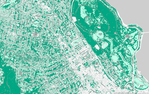
Dive into Geoneon Vegetation Mapping and see firsthand the difference our advanced AI and high-resolution satellite imagery can make. Whether you are involved in urban planning, agriculture, environmental conservation, or any field in between, our samples will demonstrate the clarity and depth of information our technology can provide.
Discover how our 10m Standard and 30cm High-Res mapping solutions can transform your approach to vegetation analysis.
Why Download the Samples?
- Compare the detail and accuracy between 10m Standard and 30cm High-Res resolutions.
- Visualise the potential of Geoneon Vegetation Mapping for your specific projects.
- Understand the quality of data that sets Geoneon apart from conventional mapping solutions.
Complete the form below to access your free samples of both the 10m Standard and 30cm High-Res Geoneon Vegetation Mapping. Start exploring the possibilities today!